Drone Survey in India: A solution for mapping and surveying industry

Surveying is considered a very important and initial step by many business houses to evaluate and analyze the specifications of their project area or land. Drone Survey in India is the latest and most popular service which is being used by many big business houses these days. Drone Survey in India provides an efficient and […]
Aerial Surveying of Solar Power Plants
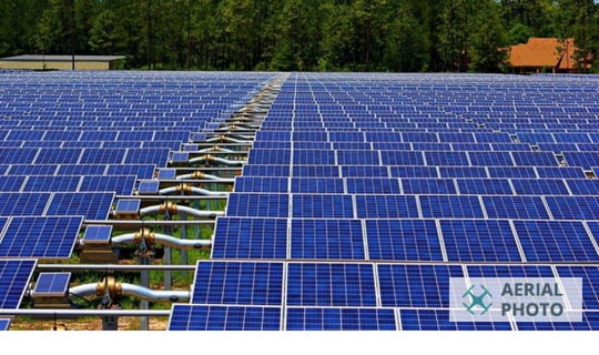
Aerial Photography of Solar Power Plants The trend of Solar Energy is increasing rapidly, and many companies are investing in solar power plants. But, When it comes to its maintenance facility, operators are spending thousands of person-hours in inspecting and finding faults in the panels. These maintenance expenses affect the solar power pricing also advancement […]
Is Drone Survey in India catching Up as Expected?

There was a time when drones were used just for military purposes, and they came into use right from the time of the Second World War. They are the perfect mechanism to capture what is happening behind enemy lines and without compromising one’s location. Later, drones came to be used for commercial purposes as well, […]
Drone Mapping in India is Helping in Making Better Survey Decisions

Is Drone Mapping in India Helping in Making Better Survey Decisions? Drone Mapping is a very advanced way of mapping a region, and it is very different from a regular map that one would buy at a store. In fact, the drone mapping technology was first tested for military operations, where exact and precise information […]
How Drone 3D Modelling in India offers Accurate 3D Models for a Clear Vision?
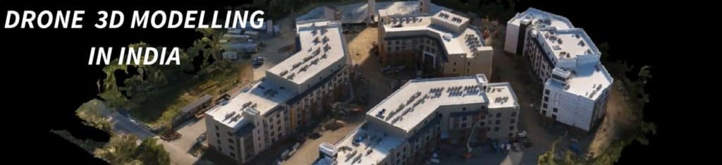
How is Drone 3D Modelling in India helping the Users? It is widely known that 3D images present a more lifelike representation than 2D ones and while one is now moderately acquainted with the concept of 3D pictures and movies, 3D modelling is something still new and in its nascent stages in most parts of […]
Drone Survey Services has Transformed Modern Aerial Photography

With an improvement of technology comes the opportunity of exploring new ways of doing things and this is what happened in the field of photography with the advent of drones. Drone Survey Services is one of the leading sought-after services today in the profession of photography and not without reason. Drones are smoother to operate, […]
Drone Mapping and 3D Modelling in India

Maps are always a way to store huge information in minimal size, but what if you will have a 3D map or model anytime, anywhere on your device. AerialPhoto has launched an initiate Drone Mapping and 3D Modelling in India. Introducing 3D Maps & 3D Model, a digital way to store area information in your […]
Drone Survey India
 Surveying is the first essential step for any business model & India is introducing himself as a new business platform for multinational companies. Initiation of Drone Engineering Survey in India is a revolutionary service offered by Aerial Photo & served all over the nation. Engineering surveys play a significant role in most of the business [...]
Aerial Survey India
 Surveying is the first essential step to evaluate the specifications of an area for a pre-defined project. Aerial Photo introduces aerial survey in India, a revolutionary application of drone, in the primary business sectors of India. Aerial Photo is one of the leading survey companies in India offering surveying services for Government Authorities, Private firms [...]